History of Westmoreland County
Volume 1
Chapter 31
Coal
![]()
Coal is by far the most valuable product of Westmoreland county. From our mines we ship coal daily in every direction. Its use has become so general and so extensive in the United States that perhaps a few words concerning its discovery and the early history of the trade may not be out of place here.
From statistics published by Richard Cowling Taylor in 1848, we learn that its first discovery in the United States was made. by the renowned Father Hennepin, a French Jesuit missionary, in 1769, who discovered it near Fort Creve Coeur. near Ottawa, Illinois. Little use was made of his discovery, but the credit of being the first to know of its existence in America is nevertheless due him.
A letter written by William Byrd, of Virginia, dated 1Iay zo, 1701, speaks of Colonel Randolph, Captain Epes, Captain Webb and others, going to see a bed of coal which at times of great rains was uncovered, but which was generally found very deep in the earth. This was in Virginia, about twenty miles above Richmond. The same writer in 1732 describes air furnaces at Massaponax, Virginia, and there first mentions the use of coal in America, though that is supposed to have been "sea coal." Lewis Evans, in 1755, published a map of what is now the Ohio Valley surrounding Pittsburgh, in which coal is shown elsewhere, but none at or near Pittsburgh, nor anywhere in western Pennsylvania. . So with Nicholas Scull's map of Western Pennsylvania,. published in rX59. Yet the use of coal was known in Pennsylvania in 1758, for Colonel Bouquet, in writing to Colonel Burd about the encampment at Ligonier, advises him to examine the country for "sea-coal," and, if none can be found, says that charcoal must be made. All coal was then designated as "sea coal." In opening a road from Christopher Gists plantation to the Monongahela river at Dunlap's creek, Colonel Burd makes several important entries in his diary. He says that "Encamping about four and one-half miles from the river, on September 21, T759, on Saturday the 22nd, they moved forward, going westward. On Saturday camp moved two miles to Cole run. This run is entirely paved in the bottom with stone coal, and on the hill on the south of it is a rock of the finest coal I ever saw. I burned about a bushel of this sea coal on my fire." Coal was formerly mined in northern England alone, and was carried to London by water, and was called sea coal for that reason. In this way it was distinguished from charcoal.
A coal seam near Pittsburgh took fire in 1765, and is said to have burned steadily for sixteen years. In William Scull's map of Pennsylvania, published in 1770, coal is marked in Berks county, and also in Pittsburgh. Furthermore, in George Washington's journal of a tour to the Ohio river, which he made in 1770, under date of October 14th of that year, he says: "At Captain Crawford's all day. We went to see a coal mine not far from his house on the banks of the river. The coal seemed to be of the best kind, burning freely, and abundance of it." Captain Crawford was the unfortunate William Crawford who afterward became the first judge of Westmoreland county, and who was burned at the stake by the Indians in Ohio. He lived at Stewart's Crossing, on the Youghiogheny river, opposite Connellsville. At that time coal was used to some extent in Virginia, and Washington was supposed to be a good judge of its quality. Later developments confirm his judgment when he decided that the Connellsville coal was "of the very best kind."
The Virginia coal mines were the first that were worked in America. The mines were on the James river, in Chesterfield county, first worked in 1750. In a Virginia Gazette of July, 1766, Samuel Davis advertises coal for sale at Richmond at twelve pence per bushel, and says it is "equal to New Castle coal." In 1776 Thomas Wharten, Jr., and Owen Biddle, of Philadelphia, were authorized to buy coal from Virginia.
In a paper read before the Historical Society of Pennsylvania, on January 4, 1785, by William F. Bush, the Penn manuscript is quoted to prove that the Penns were aware of coal in abundance around Pittsburgh in 1769. Thomas Penn, in a letter from London, dated January 31, 1769, written to Governor John Penn, says, "We desire that you order five thousand acres of land to be laid out about Pittsburgh, including the town which may now be laid out, and I think from its situation it will become considerable in time ; and that the land may be laid out to Colonel Francis and his associates and other gentlemen of whom I wrote you, as contiguous as may be and in regular angled tracts if possible." Following this, on May 12th, he wrote respecting the same survey, saying, "I would not engross all the coal hills, but rather leave the greater part to others who may work them." In 1784 the Penns still retained large tracts, notwithstanding the divesting act, and sold the privilege of mining coal in the "Great Seam" to any one on the payment of thirty pounds for such-mining lot, a lot extending back to the center of the hill. Thus was the coal trade begun in Pittsburgh.
In 1785 Samuel Boyd patented a tract of coal in Clearfield county, and in 1804 shipped the first arkload of coal down the Susquehanna river to Columbia, in Lancaster county, a distance of two hundred and sixty miles, and the fuel was a matter of great surprise" to the people of that county. The first coal sent to Philadelphia from the western part of the state was from Clearfield county, by the Allegheny Coal Company. It was taken down the Susquehanna river to Port Deposit, and thence over the Chesapeake Bay to Philadelphia. This was in the summer of 1828.
In the early years of the last century the coal mined in Westmoreland county was not worth considering. The principal fuel used was not coal, but wood, of which the country had an abundance. About 185o those who had to purchase fuel began to purchase coal, but still wood was used by the majority in heating their houses. There were hundreds of farmers who had acres of coal who nevertheless purchased it or wood from their neighbors, not knowing what lay concealed beneath the surface of their lands. Gradually the coal began to be opened in places where its outcrop was patent to the -casual observer. These openings were always what is called "drifts." These drifts were called coal banks, and the output was only to supply a limited local market, and was mined in the most primitive manner. They knew nothing of the use of explosives in mining, and in nearly every coal bank the coal was brought to the pit's mouth on a wheelbarrow, by man power.
There were a few arkloads of coal shipped from the county on the canal, but the amount was so small that it is not worth considering. When the railroad building era of the fifties came the coal industry began, though it was confined to coal fields in close proximity to the main lines. The modern idea of building a road to the coal fields was not thought of in Westmoreland county till about 1870. The southwest branch of the Pennsylvania, extending from Greensburg to Uniontown, opened up the richest field of coal in western Pennsylvania, but its projectors builded more on the richness of the agricultural region through which they were passing for freight and passenger traffic than they did on the coal, yet the coal and coke shipments have long since surpassed all others on that road. The coal industry, as it now exists, that is, the shipping coal from Westmoreland to foreign markets, was in its first stages of development when the panic of 1873 came. Little was done in the coal trade until the times began to brighten up in 1877. Then the trade, as we now know it, began to grow, and by i88o both the shipment of coal and coke had become established industries in our county. With these industries came a corresponding increase in the value of coal lands. Until these developments were made land was valued because of its location or surface; since then, the value of the land, if underlaid with coal, has increased so much that its surface value is generally lost sight of. Ten times its surface; since then the value of the land, if underlaid with coal, has increased the value of the coal depends very little, if any, on the value of the surface.
The coal mined in Westmoreland county so far has been almost entirely the vein that is geologically known as the Pittsburgh seam. It underlies the greater part of the county, and has an average thickness of about eight feet.
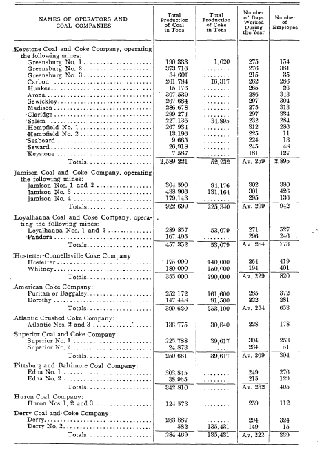
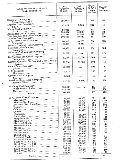
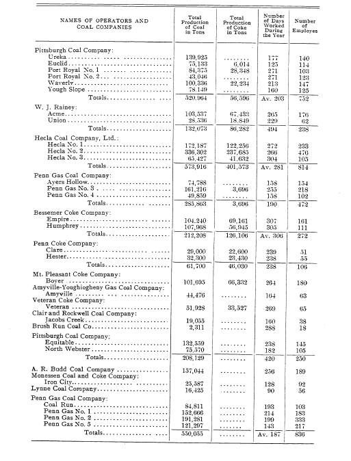
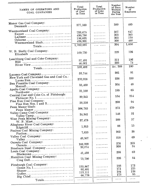
Its depth varies with localities and with the topography of the surface, but it is generally found from fifty to two hundred feet below the surface. The table here given is taken from the reports made by the mine inspectors, and published by the State Bureau of Mines. It is not absolutely accurate, but shows in the main the extent of the coal industry in our county for 1904. In the last year many new mines have been opened and have been operated to their fullest extent. Our coal fields in Westmoreland county seems to be almost inexhaustible.
Source: Page(s) 458-467, History of Westmoreland County, Volume I, Pennsylvania by John N Boucher. New York, The Lewis Publishing Company, 1906.
Transcribed August 2008 for the Westmoreland County History Project
Contributed by Nathan Zipfel for use by the Westmoreland County Genealogy Project (http://www.pa-roots.com/westmoreland/)
Westmoreland County Genealogy Project Notice:These electronic pages cannot be reproduced in any format, for any presentation, without prior written permission.
Return to Westmoreland County History Project
![]()
Return to Westmoreland County Home Page